Preamble
An interesting incident (for our studies purposes, of course) happened on March 17, 2024, as an Atsa Airlines' Dash 8-400 (DH8D) flying from Mazamari (SPMF/MZA) to Lima (SPJC/LIM), was climbing through FL170 out of Mazamari when the crew needed to shut the left hand engine down due to the loss of oil pressure (source: The Aviation Herald).
The crew decided to divert to Pucallpa (SPCL/PCL), where the aircraft landed safely. Let's try to understand this operational decision!
The Aircraft
The flight 4A-4092 was carried out with the aircraft OB-2195, a 22+ years-old Dash-8 previously owned by Horizon Air and Alaska Air, and nowadays (since June 2019) operated by Atsa Airlines.
The Dash-8 has a maximum operating altitude of 25,000 ft ASL (Above Sea Level), as indicated in the original equipment manufacturer (OEM) operation manuals. Passenger drop-down oxygen system is optional, which – if available – may increase maximum operating altitude to 27,000 ft ASL (and may also improve its operational capability over high terrains...).
For this study, let's just focus on the engine failure scenario (driftdown) independently of the depressurization scenario, although escape routes design must always consider both.
For that, we may note that the OEM publishes "singe engine service ceiling" data – which is the pressure altitude the airplane may maintain with one engine out for a given mass and temperature combination providing the relevant speed schedule is observed –, as well as tables with driftdown profiles – which are the descent path followed from cruising altitude, when the engine failure occurs, until reaching the single engine service ceiling.
Those information are essential for such preliminary studies as well as decision-making during inflight engine-out incidents, specially over high terrain, when the single service ceiling may be below the minimum safe altitude (MEA - Minimum En-Route Altitude, MORA - Minimum Off-Route Altitude).
The Route
Since there is no ADS-B data available from this flight or from any other Atsa flights between SPMF and SPJC, let's assume it was supposed to follow the Low IFR route via airway T226:

The route, hence, would have a MEA of 20,000 ft over the mountains, as indicated in the enroute chart extract from SkyVector.
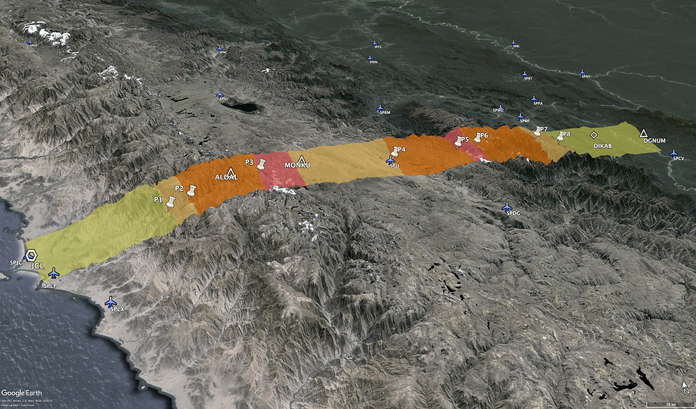
The Terrain
Still from SkyVector, a quick look over grid MORA bring some light about the terrain, as it ranges from from FL164 to FL198 within the planned route:

To better illustrate the challenging terrain, let's take a look at it in Google Earth as well, though:

We can note that most of the flight path is over terrain with more than 10,000 ft, going up to 17,005 ft, hence the published MEA of 20,000 ft.
The Analysis
To get some conclusions of the best line of action, let's first take a look at the Single Engine Climb Data for the Dash-8, considering ISA+20°C:

We can notice that, indeed, depending on the takeoff weight, the aircraft cannot reach a desired top of climb (TOC) above FL200 (which is the MEA).
Checking then the Single Engine Service Ceiling Data, for the same ISA+20°C condition, we can notice that even to keep the aircraft above FL200, a maximum takeoff weight would need to be imposed for this route, in case no diversion is intended in case of an engine failure emergency:
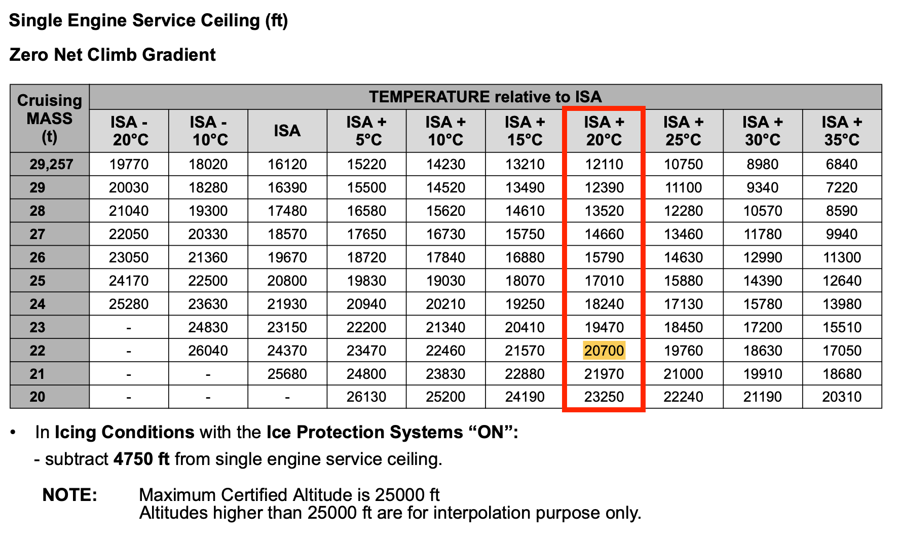
Such limitation on takeoff weight would probably jeopardize the operations to/from Mazamari, so certainly the evaluation of driftdown procedure and definition of a Point of No Return (PNR) is primordial for this route.
For that, we will consider the follow assumptions:
Temperature: ISA+20°C
From the Single Engine Service Ceiling Data, our service ceiling in that scenario is 13,520 ft (wit no icing conditions), so below our MEA (FL200).
The Driftdown Data is provided as follows. Note that the aircraft would reach FL180 within 58 NM (air distance, with no wind) from the engine failure:
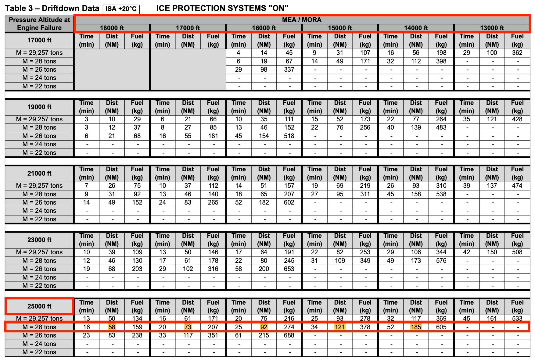
Since the route via airway T226, in which the MEA is indicated as FL200, is 188 NM in total (more than the double of 58 NM), it is clear that we need to go into more details of the terrain and "break" the minimum safe altitude into smaller segments to define the PNR of the route.
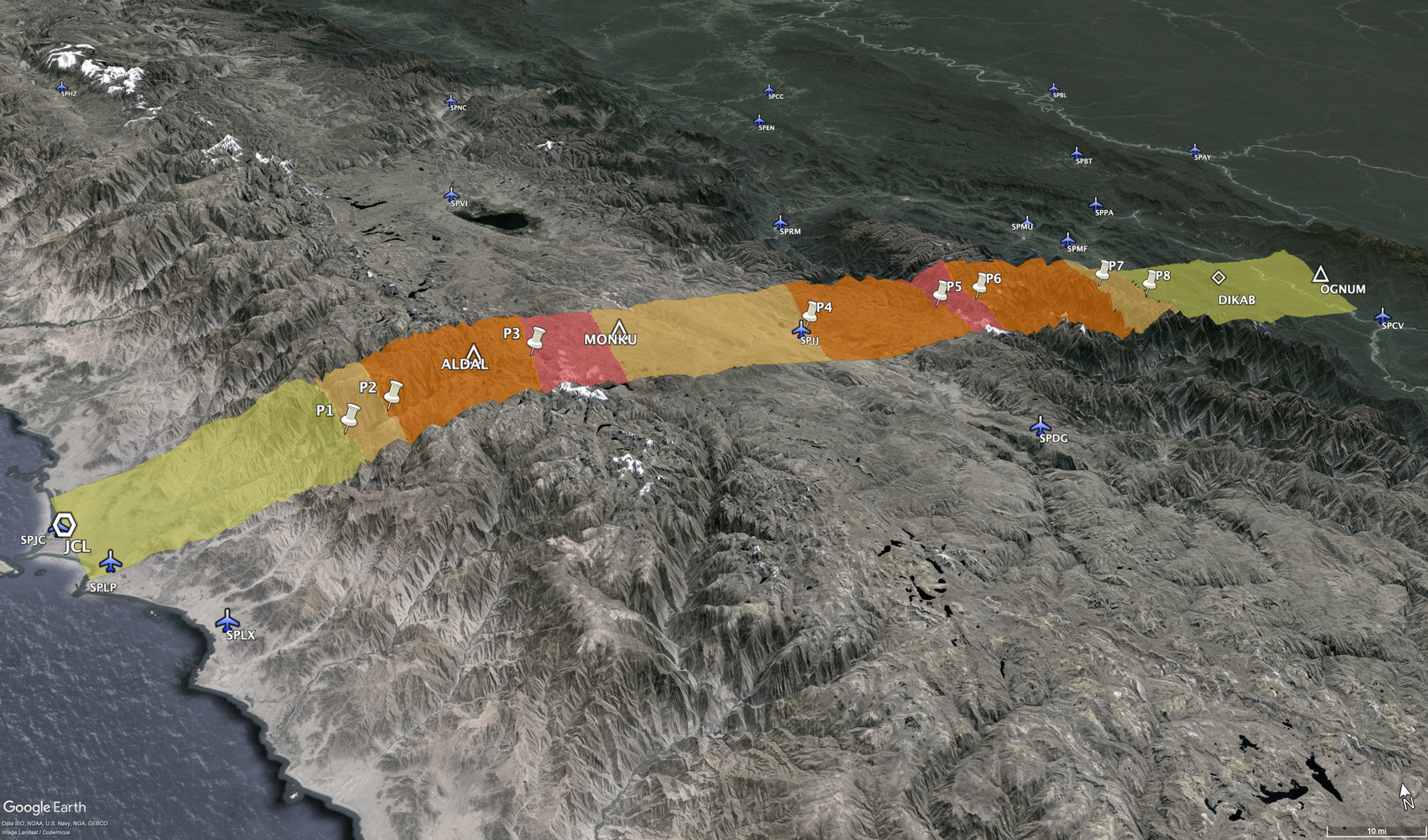
From terrain survey, and adding required margins (horizontal and vertically) from regulation, our driftdown profile will look like this:

We would, hence, have a PNR at 20 NM from MONKU 😄
Conclusions
From our analysis, we could conclude that a PNR over the high terrain should be defined and made available for the crew, and a simpler analysis based only on the published MEA wouldn't be enough to give the crew the correct line of action for a failure during cruise phase. Moreover, we found out that the PNR should be somewhere around 20 NM before MONKU.
For the incident, particularly, the engine shut down was reported to have happened during climb, so even before reaching cruise level. Based on our analysis, the decision to return along the planned route to the closest alternate should be taken.
So, why not the departure airport? Well, not only aircraft performance shall be taken into consideration in such decisions: Mazamari (SPMF) has limited resources (no fueling available, for instance), and limiting operating conditions, such as no lighting or instruments (daytime and visual conditions only), and a short runway (1,760m, 30m wide).
Pucallpa (SPCL), on the other hand, is an airport of entry with VOR approach procedures and a longer runway (2,800m, 45m wide) available, hence the (right) decision by the crew to divert to it instead.