
Preamble
On December 6, 2019, a Boeing 737-400 from Avior Airlines — a scheduled and charter Venezuelan operator — suffered a depressurization 45 minutes after takeoff from Lima, Peru (SPJC) in a direct route over the Andes to Tarapoto (SPST).
The crew, in coordination with Lima ATC, executed an emergency descent from cruise level FL330 to FL190, and subsequently to FL110, after leaving the Andes critical terrain.
With 133 passengers and 8 crew members on board, some people ended up suffering a lack of oxygen, including a six-month-old child, who was the most affected.
The investigation concluded that the depressurization was due to the obstruction of outflow and safety relieve valves caused by loose isolation blankets.
A critical contribution to the consequences of the incident was the deviation of the original flight plan to a direct route to Tarapoto VOR over the Andes, which was not covered in the operator's Route Clearance Unit (RCU) manual. The following figure shows the RCU as published by Aviator, with an indication of the direct route took by the flight ROI 1521 and the location where the depressurization occurred:

While the final report do mention that the airplane was equipped only with 12-min oxygen system (so presumably not enough to fly the direct route), it doesn't provide a detailed analysis of that:
Would a diversion be possible throughout the route?
So let's check it!
Full report can be found at: https://www.gob.pe/institucion/mtc/informes-publicaciones/1853699-informe-final-ciaa-incid-012-2019-matricula-yv3011-fecha-06-12-2019 (Spanish only)
The Aircraft
The flight ROI 1521 was carried out with the aircraft YV3011, a Boeing 737-401, with a 12-min oxygen chemical system. This system behavior, when triggered, follows a Maximum Altitude Envelope, as provided by the manufacturer.

Basically, to make sure it will provide sufficient supplemental oxygen to the passengers, the aircraft must fly at or below these altitudes after the given time after its activation, as described in such envelope.
Moreover, following a rapid depressurization, the crew must perform an emergency descent (if required), as described in the aircraft operations manuals:

The exact descent flight path will depend also of the environment conditions (temperature and wind) as well as aircraft weight, and cruise level before the descent is initiated.
The Route
From the data provided in the final report, it is possible to verify that the flight was authorized by ATC to fly via the following route: KALAR UP776 ILROL UL342 TAP (as per AIRAC cycle 2105)
The emergency descent was initiated around 20NM prior NENER, over airway UL342, when a diversion was done to ENPAP, joining airway UL305, as to then proceed to TAP and land in SPST.

The Terrain
The following image illustrates the terrain vertical profile of the planned route (in yellow), with the diversion depicted in red.
Note: no horizontal or vertical margins, as required per regulation, are represented here.
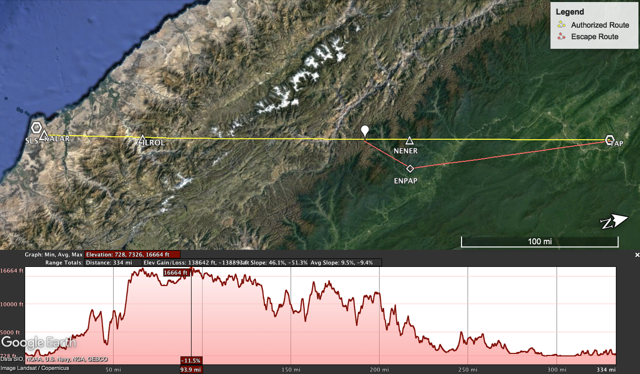
This preliminary analysis allow us to notice terrain peaks over 16,000 ft and an extensive range with terrain over 10,000 ft, which suggests we shall check for Points of No Return (PNR) within this segment between ILROL and NENER.
The Analysis
For a depressurization scenario, considering the aforementioned details about the aircraft, route and terrain, and applying the requirement of clearing the obstacles vertically by at least 2,000 ft within 5 NM of either side of the intended track, our emergency descent analysis can be depicted as below:

It is noted than that between PNR1 and PNR2 the aircraft is unable to proceed or return safely — within the regulatory margins — so a Escape Route must be designed (if possible at all...).
It is interesting to highlight that the incident fortunately happened around 20 NM prior to NENER (so around 30NM after PNR2, when continuation to planned route could be safely achieved). Acknowledging the aircraft was flying at 262 KCAS (M.74), that's about 5min!
Going further to check for feasible diversions within the critical segment between PNR1 and PNR2, a broader terrain study was done to identify favorable tracks with lower terrain profiles:
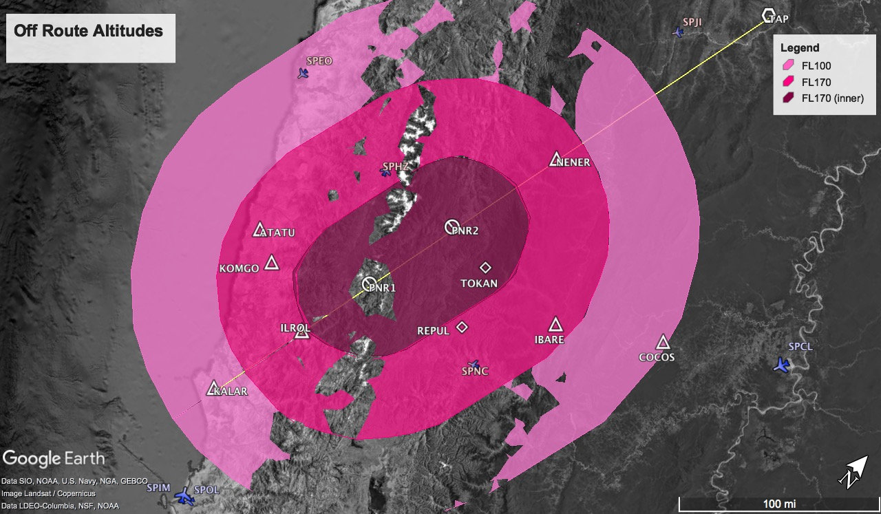
As returning or continuing via the planned route is not possible between PRN1 and PRN2, we may consider the following options:
Divert to SPHZ or SPNC
A closer look to SPHZ and SPNC makes the option 1 not so interesting, as those airports are not proper for B737 operations: narrow runway, low PCN, RFF Cat 5, no instrument aids, high terrain in all quadrants.
The option 2, to divert west, means to return and fly over the highest portion of the Andes.
The option 3, to divert east to SPCL, seems the most promising.
As the idea here is not to be long, after some iterations, we could find the following feasible solution:

Although option 2 was not the most favorable at first, the diversion between WPT1 and WPT2 toward east was not possible due to terrain (remember that grid MORA in the region is as high as FL250, so high terrain all over the place!).
A descriptive table of the proposed Escape Routes would be then:

DISCLAIMER: The entire content of this article is for study purposes only and shall not be used for operations. The liability and responsibility of its use and its consequences lie solely on you. No guarantee is offered on accuracy or precision of the results. Use at your own risk.
Conclusions
The design of Escape Routes is primordial for operation in regions like the Andes: a matter of minutes could transform an incident into an (avoidable) accident.
Based on the analysis developed herein, we could see that a proper Escape Route procedure to fly the direct route where the incident of Avior Airlines happened is possible, although it requires some off-route diversions, with really tiny margins.
The action taken by the crew didn't affect the safety of the procedure, but it may have been unnecessary, as continuing along planned route was possible within regulatory margins. But they couldn't know that, so the right decision was to divert to the lowest terrain as soon as possible...
This analysis didn't consider a scenario of engine failure (driftdown), but in this particular case, the depressurization would still be the limiting one.
We hope that the lessons-learned from this incident bring us toward an even safer aviation environment!